Extreme Weather/Climate
L. David Roper
http://www.roperld.com/personal/roperldavid.htm
6 April, 2016
"Climate is what you expect; weather is what you get."
Contents
Introduction
One definition of climate is " the composite or generally prevailing weather conditions of a region, as temperature, air pressure, humidity , precipitation, sunshine , cloudiness, and winds, throughout the year, averaged over a series of years." So, extreme climate is a compilation of extreme weather over a series of years.
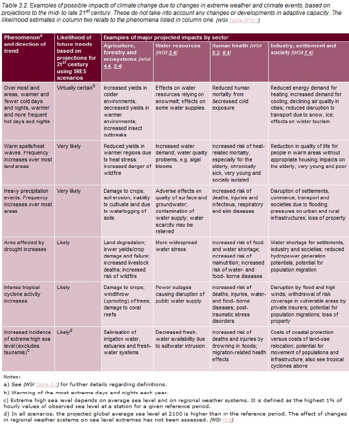
The Intergovernmental Panel on Climate Change, which consists of thousands of climatologists, has given predictions of extreme weather events due to global warming in the 2007 report. Here is a summary:

The year 2010 slightly exceeded 2005 as the hottest year on record; it will probably go down in history as the year when it was realized by most of the public that extreme weather was evidence of global warming:
U.S. Climate Extremes Index
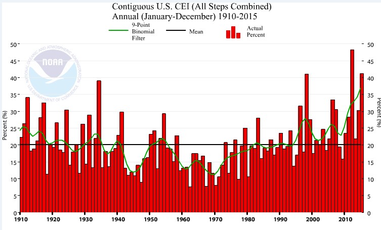
NOAA has devised a Climate Extremes Index (CEI) for the United States:

The dip from ~1950 to ~1980 was due to global dimming due to aerosols in the atmosphere due to fossil-fuels burning before clean-air legislation:

I have done a study of the increase in tornadoes over time in the United States.

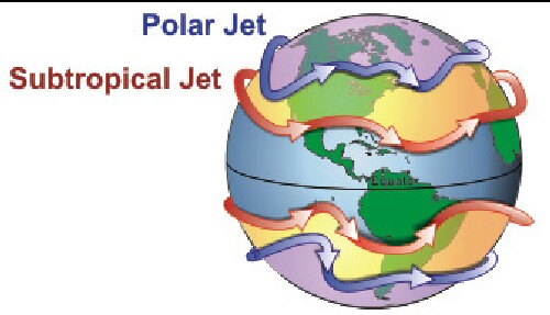
Both the northern and southern hemispheres have polar jet streams (altitude 7-12 km = 23,000-39,000 ft) and subtropical jet streams (altitude 10-16 km = 33,000-52,000 ft) that move from west to east at varying speeds up to nearly 400 km/hr = 249 mi/hr = 216 knots.

Jet streams stear storm systems in the lower atmosphere, so it is important as to the paths that they follow.
Research has begun on how the jet streams' paths are changed by global warming. Data indicate that the jet streams are slowly rising in altitude and moving toward the poles, but are dipping into the deep south during winters causing severe winter weather. The movement toward the poles means that the dry areas are moving toward the poles.
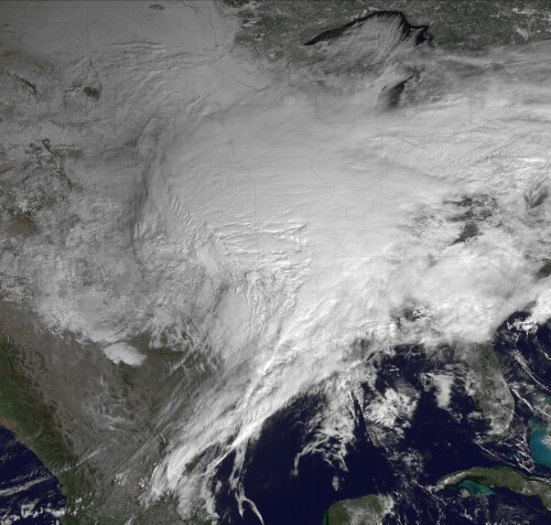
The increased temperatures in the arctic regions cause high pressure there, which causes the jet stream to dip into lower latitudes bringing cold arctic air with it. So both North America and Australia can have cold winters with much frozen precipitation. (Current Weather Blast Likely Intensified by Rising Global Temps)

Changing Jet Streams May Alter Paths of Storms and Hurricanes.
The precipation increases because the higher global temperatures evaporates more water into the atmosphere. Also, see this.
References
- What Insurance Companies Already Know about Climate Change
- Managing the Risks of Extreme Events and Disasters to Advance Climate Change Adaptation
- Link Builds Between Weather Extremes and Warming
- Current Extreme Weather & Climate Change
- Video about Climate Change & Extreme Weather
- Extreme Weather/Climate
- Extreme Weather: Tornadoes
- Droughts in the United States
- NOAA U.S. Climate Extremes Index (graphs)
- National Climate Extremes Committee
- NOAA: 2010 State of the Climate
- 5 myths about extreme weather
- http://en.wikipedia.org/wiki/Extreme_weather
- http://en.wikipedia.org/wiki/File:Trends_in_natural_disasters.jpg
- http://www.nasa.gov/centers/goddard/news/topstory/2007/moist_convection.html
- http://www.wsi.com/Collateral/Documents/English-US/WSI_severestorm_Index.pdf
- http://www.theweatherprediction.com/severe/indices/
- https://www.cfa.harvard.edu/~wsoon/DaveLegates03-d/Ballingetal03.pdf
- http://ff.org/centers/csspp/library/co2weekly/2005-05-26/extreme.htm
- http://www.pewclimate.org/hurricanes.cfm
- http://www.sciencedaily.com/releases/2007/12/071204121949.htm
- http://www.sciencedaily.com/releases/2008/12/081227214927.htm
- http://www.nasa.gov/centers/goddard/news/topstory/2007/moist_convection.html
- http://www.ipcc.ch/publications_and_data/ar4/wg2/en/ch8s8-2-2.html
- http://www.jpl.nasa.gov/news/news.cfm?release=2008-242: For every degree Centigrade (1.8 degrees Fahrenheit) increase in average ocean surface temperature, the team observed a 45-percent increase in the frequency of the very high clouds. At the present rate of global warming of 0.13 degrees Celsius (0.23 degrees Fahrenheit) per decade, the team inferred the frequency of these storms can be expected to increase by six percent per decade. Aumann said the results of his study, published recently in Geophysical Research Letters, are consistent with another NASA-funded study by Frank Wentz and colleagues in 2005. That study found an increase in the global rain rate of 1.5 percent per decade over 18 years, a value that is about five times higher than the value estimated by climate models that were used in the 2007 report of the Intergovernmental Panel on Climate Change.
- http://www.spc.ncep.noaa.gov/gis/svrgis/: This page has the United States severe report database (tornadoes 1950-2009, hail/wind 1955-2009), converted into shapefile (.shp) file format as well as a Geographic Information System (GIS) database. Additional data available for download include census and topographic datasets, among others. The data can be viewed in graphical, tabular, and statistical formats depending on end-user programs.
- http://www.ncdc.noaa.gov/oa/climate/severeweather/extremes.html
- http://climatesignals.org/2010/09/extreme-weather-driven-by-jet-stream-shift-consistent-with-global-warming/
- Frigid winter thanks to Arctic Oscillation of Jet Stream
- Cyclones spurt water into the stratosphere, feeding global warming
- Managing the Risks of Extreme Events amd Disasters to Advance Climate Change Adaptation
- Extreme weather: Is Arctic sea ice loss partly to blame?
- The Carbon Bomb
- Rising Sea Levels Raise Risk of Record Floods
- How cllimate destruction harms lower-and-middle-income families
L. David Roper interdisciplinary studies
Roper Global Warming
L. David Roper, http://www.roperld.com/personal/roperldavid.htm
6 April, 2016
